 Fsbuild 2.3 Features


Last Updated Nov 20 2006.

System Requirements:
Minimum:  Pentium 700,  384 MB RAM, 80 MB HD space.
Win98, WinNT4/2000, WinXP

Fsbuild 2.3 is now available at SimMarket.com

--------------------------------------------------------------------------------------------------------------
Features Overiew
Last Updated Nov 20 2006.
System Requirements:
Minimum: Pentium 700, 384 MB RAM, 80 MB HD space.
Win98, WinNT4/2000, WinXP
Fsbuild 2.3 is now available at SimMarket.com
--------------------------------------------------------------------------------------------------------------
Features Overiew
Map view to graphically display created flight plan routings and available Navaids airways, SIDs and STARs.
Enhanced coded route interpreter, interpret various coded route/Flight Plan formats
Flexible automatic route generation, can auto generate complete flight plans from scratch between DEP/DEST, as well was generate a route between two or more defined points.
Grapical SID/STAR display to assist in determining best SID/STAR route for direction of flight.
Airway, and Navaid Search in user specified Map areas for efficient route planning.
'Plan mode' feature allows use of the Map view for manually creating flight plans from scratch using Navaids, Airways, SIDS and STAR's.
Optional Step climb calculations for long range Flights.
20,000+ ready to use flight plans included.
Easy access to flight plans stored on the websites for easy copy/paste directly into Fsbuild.
Import routes created with external Flight Planners/Flight Planning web sites
Entire FAA Preferred IFR routes and Severe weather routes database included (can be easily updated by a download from FAA's web site).
Canada Preferred IFR routes database included.
DFS standard routes database included.
Support for insertion of daily, and static North Atlantic and Pacific Track routings into Flight Plans.
Exporting of flight plans to several FlightSim, and FlightSim add-on formats.
Aircraft performance calculations climb cruise, descent, and fuel.
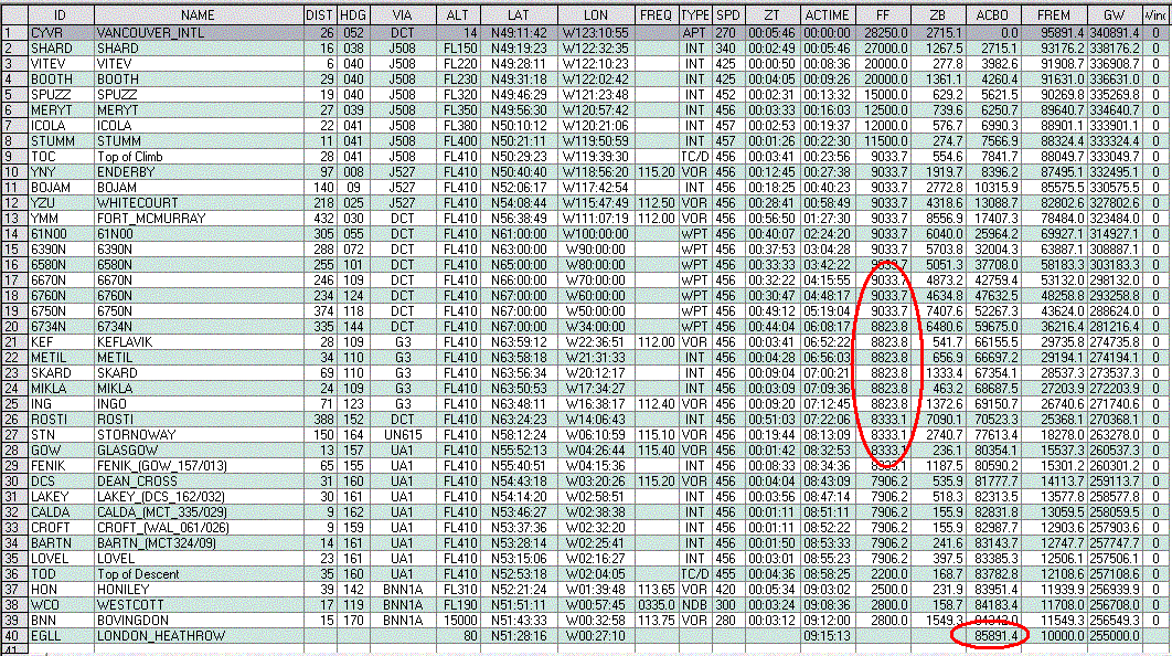
Detailed Navigation log with aircraft climb, cruise,descent, and fuel performance information included.
Performance calculations adjusted for Winds aloft forecast at each waypoint (Available for SimWx, FSMeteo, ActiveSkyWxRe, ActiveSky 2004, and Weather Center2)
Can be used with X-Plane,FS2002,PS1,FLY!2 Flight Simulators.
Features Details.
----------------------------------------------------------------------------------------------------
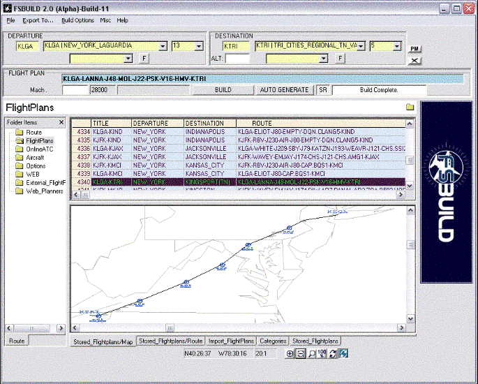
FLIGHT PLANS
----------------------------------------------------------------------------------------------------
STORED
Database of 20,000+ ready to use stored flight plans included.
Save/Delete user created Flight Plans.
Log kept of recently Created/Built Flight Plans for easy retrieval and reuse.
CATEGORY
Support user definition of stored flight plan categories linked to user defined flight plan files.
Search/Filter flight plan list display by departure, destination airport city name or ICAO code
BUILD
Enhanced coded route interpreter, interprets various coded Route/Flight Plan formats.
Route Plotted over World Map after each Flight plan build.
Flight Plan waypoints displayed in active route table/grid after each build.
Manual Flight plan creation using Navaids, Airways, SID's and STAR Identifiers.
Map view automatically re-zooms to show only area between deprture and destination after each build.
Optionally Include or Exclude SID or STAR from route during build.
Step climb profile can be calculated for long distance routes.
Optionally insert TOC/TOD waypoints into flight plan.
Performance calculations adjusted for Winds aloft forecast at each waypoint (via fsmeteo, SimWx, ActiveSkyWxRe).
Fuel 'Bias' adjustment support for use with different variants of the same aircraft type.
Expanded cruise fuel performance support (fuel flow calculations adjusted as aircraft's gross weight changes in cruise).
Automatically selects cruise alt based on aircraft capability, and direction of flight odd-even altitudes (RVSM option as well).
Automatic SID/STAR version number correction during Build.
Build Flight directly from route/table grid option to support user defined waypoints, and to specify certain Navaids.
Coded Flight Plan automatically placed in windows clipboard after build (optional) for squawkbox 2 users to paste flight plan int SB's flight plan dialog.
Route heading/bearing calculations adjusted for magnetic variation.
User defined fixes/waypoints supported using various lat/lon formats.
Automatic Export of flight plans to several FlightSim, and FlightSim add-on formats after build completion.
Configure default taxi times for specified airports, FSbuild will automatically calculate the taxi fuel for your departure.
AUTOROUTE GENERATOR
Auto generate complete flight plans from scratch between DEP/DEST.
Automatically selects stored flight plan route when dep/dest matches stored route (option can be disabled).
Wildcard option to allow single or multiple legs (or gaps) of a partial route to be autogenerated.
Recognizes single direction airways during auto-generation, and avoids wrong direction airways.
Automatically selects appropriate SID's STAR's and airways for route.
SID/STAR selection only includes SID/STARs available for the selected runway.
Optionally can Include/Exclude SID/STAR from flight plan autogeneration.
Takes into account preferred departure and arrival routings at specified airports (preferred DEP/ARR routes can be user defined).
Automatically selects or low high alt airway routes based on cruise altitude.
In plan mode auto generated routes can be modified for error correction or fine tuning by the user.
PLANNING/CREATING (PLAN MODE)
Plan Mode for manual creation of Flight plans using Map view display.
Each route modification or change is automatically replotted on the map display, so you can immediately see how your modification affects the routing.
Coded or ATS representation of route automatically updated with each route modication or change.
Route waypoint table automatically updated with each route modication or change.
Automatic new waypoint positioning. No need to drag and drop or specifically place selected navaids at a certain spot as Fsbuild knows exactly the appropriate place to position a selected Navaid in the Flight Plan.
Current stored or coded route built automatically when entering plan mode for easy modification existing or stored flight plans.
Great circle route optionally generated as a guide for long distance route planning.
Can manually type in airway by Identifier and have it highlight on map for better airway route identification/selection.
Current North Atlantic/Pacific Tracks graphically displayed in map view
Can insert todays Daily North Atlantic (NATS) Tracks routes into Flight Plan.
Can insert todays Daily Pacific Oceanic (PACOTS) Tracks routes into Flight Plan.
Available North Altantic Track Altitudes selectable from pulldown menu.
Can optionally select static North Atlantic Tracks used by online ATC organizations into flight plan.
Static Concorde North Atlantic Tracks can be selected and inserted into your flight plan.
Search specified Map area for Navaids, and Airways, search results can be inserted into the flight plan.
Airways can be inserted into flight plan by specified airway route segment (From,Via,To)
Automatic display of appropriate SID/STARs when new airport or runway is selected.
Can define display of airways that pass over a specified Navaid, for easier route planning via the Map.
Airway routes displayed highlighted on map upon selection for better indentification.
Automatic Insertion of selected SID/STAR route into flight plan.
SID/STAR airways highlighted when selected for better identification.
SID/STAR transitions highlighted on map separately upon selection.
SID/STAR and Airway waypoints highlight individually on map upon selection
Airway Map lines can be ID'd by mouse selection on map for better clarification of which map line represents which airway.
Airway waypoints highlight individually on map upon selection
Airways SID's, STAR's and Navaids can be identified on map no matter what the zoom level is. Allowing for better use of these items over longer distances.
Single Direction Airways displayed on Map with directional arrows indication route direction.
Insertion of lat/lon Map cursor position into flight plan as waypoint.
DISPLAY
Grapical SID/STAR display to assist in determining best SID/STAR route for direction of flight.
Map view to graphically display created flight plan routings and available Navaids airways, SIDs and STARs.
Route Waypoint highlighting, so you can see exactly where each waypoint in your flight plan is located geograhically.
'FL' notation displayed when route waypoint is at or above defined transition altitude for the departure/arrival area
Online ATC situation display view (Only Vatsim supported at this time)
Insert user configurable web sites into Fsbuild user interface.
EXPORT
Exporting of Flight Plans to various FlightSim FMS/GPS add-ons.
Exporting formats available:
ACS-GPS
Aerosoft L1011 FMS
Aerowinx PS1.3 (.rou and .via option)
Flight1 ATR72
FlightSim Commander
FLY!II Planner
FPI ATOC
FS2000/02/04 Planner (.pln)
FSACARS
FSINN
FSNavigator 4
FSX Planner (.pln (xml))
GPS98
iFLY 747
IVAP
ISG FMS/MCU
Lago MD80 Maddog
LevelD 767 (767PIC)
Navdata/RealCRT (FS2002)
PMDG 777/757 for FLY!II
PMDG 737NG 737-600/-700, for FS2002/FS2004
PMDG 747-400, for FS2004
PSS A320
PSS 747/777 (FS2002)
PSS 757/777 (FS2004)
PSS Route (Dash 8)
SquawkBox 3
SSW A310
vasFMC
X-Plane 6.2+/7.1+ FMS
X-Plane 8+ FMS
XSquawkBox
IMPORT
Importing of Flight Plans from various formats.
Squawkbox
FS2000
767PIC
PSS 747/777
PSS A320
PSS Route
PS1.3
.via option availabe for PSSA320,PSS Route (DH8), PS1.3, 767PIC, and FS2000 .PLN to import the route in ATS or coded formats.
----------------------------------------------------------------------------------------------------
AIRCAFT DATA/PERFORMANCE
----------------------------------------------------------------------------------------------------
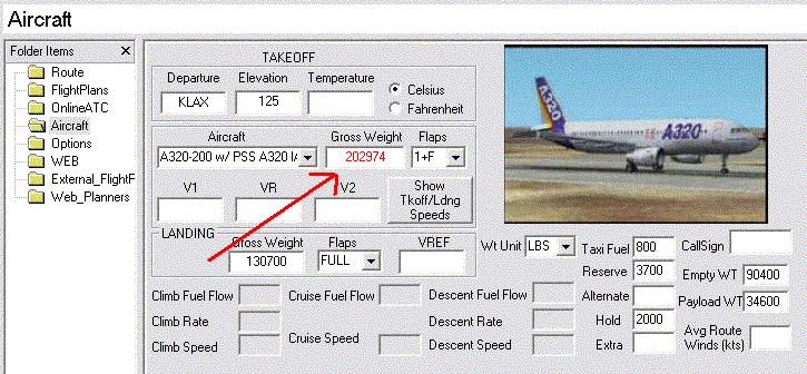
Detailed Aircraft, time, and fuel performance calculations (user customizable).
Takeoff and Landing V-speed calculations based on gross weight, elevation, temperature, and flaps settings.
Takeoff Gross weight automatically recalculated when fuel or payload weight values are modified.
After Build, Takeoff and landing Gross Weights are adjusted to include the projected fuel use for the flight.
If Max takeoff and landing Gross weights are exceeded user is notified by highlighted them in red.
Detailed Aircraft Performance data included initially for,several Airliners.
Optional Step climb calculations for long range Flights.
Cruise performance/fuel flow changes as aircraft's gross weight changes during cruise.
Performance calculations adjusted for Winds aloft forecast at each waypoint (Available for SimWx, FSMeteo not available yet)
Performance data can be customized for a specific Flight Sim aircraft model.
----------------------------------------------------------------------------------------------------
NAVDATA
----------------------------------------------------------------------------------------------------
Database of SID's and STAR's, and Airways, Airports and Navaids included.
Preferred arrival and departures routings included for many airports (user customizable).
Complete High and Low alt Airways database.
US Socal TEC routes
US and Canada Preferred IFR routes.
VOR's, NDB's, and Intersections, and Airways databases will be updated every Airac cycle via Richard Stefan's Navdata service.
Program Database is simulator independent, can use the same database for different FlightSims.
Entire FAA Preferred IFR and Severe weather routes database included (can be easily updated by a download from FAA's web site).
----------------------------------------------------------------------------------------------------
MISC
----------------------------------------------------------------------------------------------------
Support of FL notation for user defined cruise altitude box.
Pulldown menu available when entered Navaid ID contains multiple ID's in the database (waypoint table/grid).
Can define Magnetic year used in magvar adjustments (range 2000-2005).
Displays latitude longitude position of cursor on map, automatically adjusts display when mouse moves.
Flight Plan Navlog printout with optional export to .pdf format.
Navlog can be customized to include your own or your organizations logo .
SID/STAR menu displays in synch with runways that support them as runway selection changes so does SID/STAR menu.
Map Zoom factor displayed.
Detailed Navigation log with aircraft climb, cruise,descent, and fuel performance information included.
Navlog includes column to display ARTCC/FIR sector for each Flight Plan waypoint
Optionally to display user defined aircraft callsign in Navlog
Import directly from multine ICAO/telex route format
Import directly from the numerous websites and applications that store or generate flight plans in coded format.
Import routes created with 'RoutFinder' website.
Automatic flight plan destination alternate selection (user confugurable).
Activity Log (to keep track of recently created flights)
Revision option for X-Plane. Since X-Plane does not support loading flight plans from previous versions, you can
specifiy which X-Plane revision you currently have, so X-Plane will load Fsbuild generated plans in your release.
Easy access to flight plans stored on various flight plan/planning the websites for easy copy/paste directly into Fsbuild.
Miniplan version of Navlog can optionally be exported to FS2002's Kneeboard notes file
with the abbreviated route and takeoff and landing data (v-speeds) information.
Navlog text automatically copied in X-plane 6 folder for loading Navlog to display inside X-Plane 6.5
Batch Build option to Build a list of Flight plans in sequence.
Fsbuild2 can optionally use RVSM Flight Levels.
----------------------------------------------------------------------------------------------------